1: Beyond the Border
Notes and Acknowledgements for the Third Edition || 2: Cananea >>
A Monday in October, 1990. Perfectly sunny today, after the rains from the remnants of a tropical storm
from the west, the day before. A good day for seeing the sights in Mexico
City’s historic center, from both the recent and the ancient past.
Just paved, the Plaza de la Constitución, also informally called
the Zócalo. At its north, the Metropolitan Cathedral, the symbol of the religious
authority of Spain. Around the corner to the east, the symbol of its political
authority, the Viceregal Palace, which became the National Palace when Mexico’s
independence became complete in 1821. 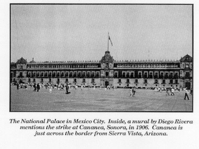 To the north of the Zócalo, the Templo Mayor, or Main
Temple, of the Aztecs. Destroyed by Spain and the enemies of the Aztecs in 1521, the
ruins of the temple remained covered until they were accidentally unearthed in 1978.
To the north of the Zócalo, the Templo Mayor, or Main
Temple, of the Aztecs. Destroyed by Spain and the enemies of the Aztecs in 1521, the
ruins of the temple remained covered until they were accidentally unearthed in 1978.
After walking across
the Zócalo, I stood by the cathedral and admired its work. Next, I went to the
temple. I marveled at the craftsmanship of the objects, as pots and jewelry, in the
museum in the front of the complex. Then, I took the walkway, which went around the
rooms and buildings of the temple.
I walked back to the
National Palace.
To the left of the
entrance, there was a stairwell, going to the second floor. A section of a mural,
with a street scene from the beginning of the 20th century. Stores, along
with offices of British and American oil companies. Derricks in the back of the
offices of the oil companies. The street was filled with people. In the crowd
was a man with bullets around his shoulder, holding a rifle in one hand, and a banner in
the other.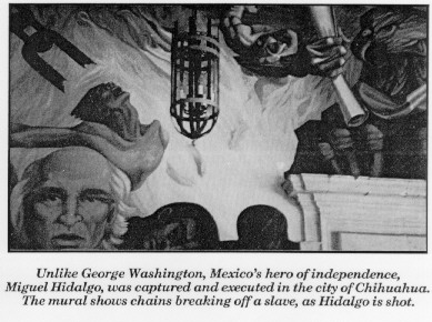
The banner listed
six events that led to the Mexican Revolution, according to Diego Rivera, the painter.
At the bottom was the miners’ strike in Cananea, Sonora in 1906.
Cananea, just 75 miles from Sierra Vista by road, no farther from Sierra Vista than
Tucson. In two days, I would start the journey of 1,600 miles to return to Sierra
Vista from Mexico City. What is on the other side of the border here? What has
made it what it is today? What do we really know about the people there, who come
across to shop in our stores and buy our products? We came up with an acronym
for our attempts to streamline commerce with them, NAFTA, the North American Free Trade
Agreement, even before the agreement was finally approved in the United States and Mexico.
Events happened in
the towns south of the border here, that are important to the history of all of Mexico.
Since many of these events were so destructive, they are better recorded north of
the border than in the towns themselves. As they prepare for what people in
Mexico’s conservative and centrist streams of politics hope will be quick and smooth
going for NAFTA, their infrastructure has improved greatly. Still, the towns are
dealing with the events that happened in them years ago.
In this writing, the towns across the border here are presented in
the order when their most important historical events happened. Cananea, with the
strike of 1906, is first. Next is Nacozari, where Jesús García sacrificed his own
life to run a train with burning cars filled with dynamite out of town a year later.
Then, Nogales, where the defeat of the federal troops in an early part of the Mexican
Revolution assured Alvaro Obregón the finances from customs revenues to seize Mexico City
more than a year later. Naco, where forces loyal to Pancho Villa faced troops loyal
to Obregón and Plutarco Elías Calles for two and a half months in 1914 and 1915, is
afterwards. Next, Agua Prieta, where Pancho Villa opposed future Mexican presidents
Calles and Lázaro Cárdenas in person later in 1915. Finally, other towns in
northeastern Sonora—Santa Ana, Magdalena, Imuris, Sásabe, Santa Cruz, Fronteras and
Esqueda, Cumpas, Ures, and Arizpe.
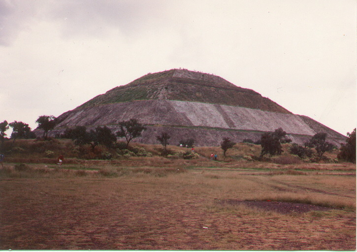 The Pyramid of the Sun, just Northeast of Mexico City.
Just down the road, archaeologists were trying to find out more about who the builders
were. They are sure that they lived from about 300 B.C. to A.D. 900.
The Pyramid of the Sun, just Northeast of Mexico City.
Just down the road, archaeologists were trying to find out more about who the builders
were. They are sure that they lived from about 300 B.C. to A.D. 900.
After Tenochtitlán, the Aztec capital, was destroyed, and Mexico
City built on top of it, Mexico’s Spanish colonizers crushed everyone, enemies and
friends of the Aztecs alike. The highest officials of New Spain were always sent
from the mother country. After almost 300 years, people of European, native,
and mixed descent born in Mexico took advantage of Spain’s problems with itself and
with Napoleon in France to rebel.
What if one event in history had happened differently? Not the
war for Texas independence in 1836, by which residents of eastern Albuquerque and Santa Fe
have to remind their guests that they are in New Mexico in the U.S.A. Not the war
of 1846-48, called in most histories in Mexico the American Intervention, by which Los
Angeles and San Francisco in California, Las Vegas and Reno in Nevada, Salt Lake City and
my college town of Logan in Utah almost 1,000 miles north of Sierra Vista, Farmington and
western Albuquerque in New Mexico, and Phoenix, Arizona are now in the United States
instead of Mexico. Not the Gadsden Purchase of 1853, by which Tucson, Sierra Vista,
and most of the rest of southeastern Arizona are in Arizona rather than Sonora. Not
the Civil War in the United States or the French Intervention in Mexico, which occurred at
the same time. Not the Mexican Revolution of 1910, as large and tragic as the
military action in it was.
The area of the Louisiana Purchase belonged to Spain in 1800.
Spain then ceded it to France, its northern neighbor, in a vain attempt to appease
Napoleon to stay out of the homeland. Needing cash after he lost several battles to
Britain in the West Indies, Napoleon sold the area to the United States three years later.
What if Spain had kept the area, and Mexico assumed it when it
completed removing Spain 21 years later?
Where Colorado Springs and Denver, and Casper and Cheyenne, Wyoming
are would have been in Mexico. Great Falls and Billings, Montana. Bismarck
and Fargo, North Dakota, and Rapid City and Sioux Falls, South Dakota. Omaha and
Lincoln, Nebraska. Minneapolis would have had a Spanish name, and it and St. Paul
would have been international twin cities, as El Paso and Juarez are today. Further
down the Mississippi, Davenport and Bettendorf, Iowa would have joined Moline and Rock
Island, Illinois as Quad Cities in two countries. Going south, St. Louis, and to
the west, Kansas City, Missouri. Little Rock, Ft. Smith, Hot Springs, and Hope,
Arkansas. Alexandria and Shreveport, Louisiana. Moving north and west, Tulsa
and Oklahoma City, and Topeka and Wichita, Kansas.
A history of popular music in Mexico describes singer Alberto
Vázquez as an imitator of Elvis Presley. If Mexico had kept the area just west of
the Mississippi, would Alberto have built a mansion in Chatfield, Arkansas, just 10 miles
of where Elvis built Graceland in Memphis, Tennessee? Would Elvis have been
considered an imitator of Alberto? Would Elvis Presley, and Alberto Vázquez, even
have existed at all? In a recent history of popular music in Mexico, written in
English, the American writer chose not to mention Alberto Vázquez, but he mentioned many
others. What other American, and Mexican, musical figures would have not existed,
had Mexico been able to keep the area immediately west of the Mississippi now in the U.S.?
Then again, if Spain had held the area, would Miguel Hidalgo have
attempted to go to the United States in 1811 to get arms when he began to fail in his
battles for Mexican independence, if he knew that he would have to go farther east than
St. Louis or New Orleans?
As it was, Hidalgo was captured, taken to the city of
Chihuahua about 240 miles south of El Paso, and shot there. After they removed Spain
10 years later, military leaders and politicians of all stripes fought over who would rule
Mexico for 55 years. The complete conquest of Mexico by the United States in 1846
and 1847 was made much quicker because many local warlords preferred anyone to Antonio
López de Santa Anna, the most prominent commander of the time. When Benito Juárez
became president and stooped payment on debts owed by previous leaders to France in 1862,
France tried to take over and rule through an emperor its forces brought with them,
Maximilian. As some say Hidalgo was trying to do eventually, Juárez returned from
the north, and had Maximilian shot.
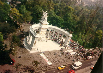
The Juárez Hemicycle at the Alameda Park in Mexico
City. In 1867, Benito Juárez finished removing Maximilian and France from Chapultepec
Castle and Mexico. Juárez is one of Mexico's two biggest heroes, with Miguel Hidalgo,
Mexico's hero of independence. The demonstrators were assembling as the "Pact Against
Hunger" to march on the National Palace, 1 mile east.
In 1876, Porfirio Díaz, a general from the southern state of
Oaxaca, took over, and ruled for 35 years until Francisco Madero forced him out in the
early days of the Revolution. Most of Mexico’s railroads, ports, and mines were
developed during this time. Foreign developers could do anything they wanted, as
long as Díaz and those he installed in power through all Mexico retained political
control over their own domains. American investment in Mexico soon outstripped
investment from Mexicans themselves.
Very little of this wealth got to the people. Only one in six
Mexicans could read and write. Landowners broke up village lands in different ways
around the country, took them over, and built up haciendas. Villagers were
left with debts to the landowners, and the army and the rural police force, the rurales,
would forcibly return to these lands anyone who tried to escape. There were
continuous local rebellions. Mayas from the southeast were deported to the mines in
the southern part of the state of Sonora, and Yaquis from southern Sonora were deported in
the opposite direction to work henequen plantations.
It is estimated that 1.5 million, or one out of eight people in
Mexico, were killed, or fled Mexico in the years of the Revolution from 1910 to
1920. Had the Civil War happened on this scale in the United States, 4 million would
have been killed or fled, instead of 600,000.
Most of the national figures left in Mexico in 1920 came from
Sonora—the state in Mexico opposite along the border to Arizona. They were
gradually removed in favor of figures from the area between Guadalajara, 1,200 miles
south, and Mexico City. Many less prominent leaders held areas as generals, or as
labor or agricultural leaders. The leaders formed the Institutional Revolutionary
Party, or PRI, for two reasons—to try to make sense of what happened in the
Revolution, especially from 1910 to 1920; and to compete politically instead of militarily
for control of Mexico, as happened through 1935.
Mexico is still reforming politically. Governors of all of
Mexico’s 31 states belonged to the PRI, until candidates from the conservative
National Action Party, or PAN, were awarded victories in Baja California Norte in 1989,
and in Chihuahua in 1992. The liberal Democratic Revolutionary Party, or PRD,
received many seats in both houses of the federal Congress in 1988, and the PAN got many
more than it had. There are many smaller political parties in Mexico. Through
the system of proportional representation, these parties were given seats in the Congress
in 1988, and again in the midterm elections of 1991. In 1993, Mexicans were given
photo voter registration cards, in the hope of ending the charges of voter fraud of which
all parties have accused each other of after every election. In 1994 before the
elections, the federal Senate was expanded, in the hope that there would be more members
both from the PRI and its national opponents. This July 2, 2000, Vicente Fox of the
PAN was elected president. Fox took office on December 1 of this year. He is the grandson
of an Irishman who came and started a ranch that raises chickens and ostriches as well as
cattle near Leon, about 200 miles north of Mexico City in 1913, just after the Revolution
started. Fox's grandfather was more successful there than Pancho Villa, who was there two
years later. The PRI will still hold more offices in Mexico than any other party.
Notes and Acknowledgements for the Third Edition || 2: Cananea >>